
Datasets on this page were produced by China Marketing Research Co. Ltd as part of the University of Michigan China Data Center Statistical series. The files consist of administrative boundaries, data associated with those boundaries, and major geographical features. If you use this data, you must cite UM CDC as the source.
| Warning |
|---|
Datasets on this page are copyrighted for use by current Baruch students, faculty, and staff for non-profit, educational, and research purposes. Commercial use and redistribution of the data is prohibited. These datasets cannot be distributed publicly over the Internet; current members of Baruch College should use their Baruch email address and contact the geospatial data librarian to access restricted datasets. If you are NOT affiliated with Baruch College CUNY you may NOT request access. |
Datasets on this page were produced by China Marketing Research Co. Ltd as part of the University of Michigan China Data Center Statistical series. The files consist of administrative boundaries, data associated with those boundaries, and major geographical features. If you use this data, you must cite UM CDC as the source.
2000-2010 China Province Population Census Data
...
| Name | Features | File Type | Year | File Name |
|---|---|---|---|---|
| Admin boundaries | polygons | shapefile | 2012 | chinaln.zip |
| Highways | lines | shapefile | 2012 | hiway.zip |
| Major Rivers | lines | shapefile | 2012 | driver.zip |
| Provinces & Population Data | polygons | shapefile | 2012 | CensusProv_2000_2010.zip |
| Provincial Trunk Roads | lines | shapefile | 2012 | sd.zip |
| Railways | lines | shapefile | 2012 | rail.zip |
| Rivers | lines | shapefile | 2012 | river.zip |
| State Roads | lines | shapefile | 2012 | gd.zip |
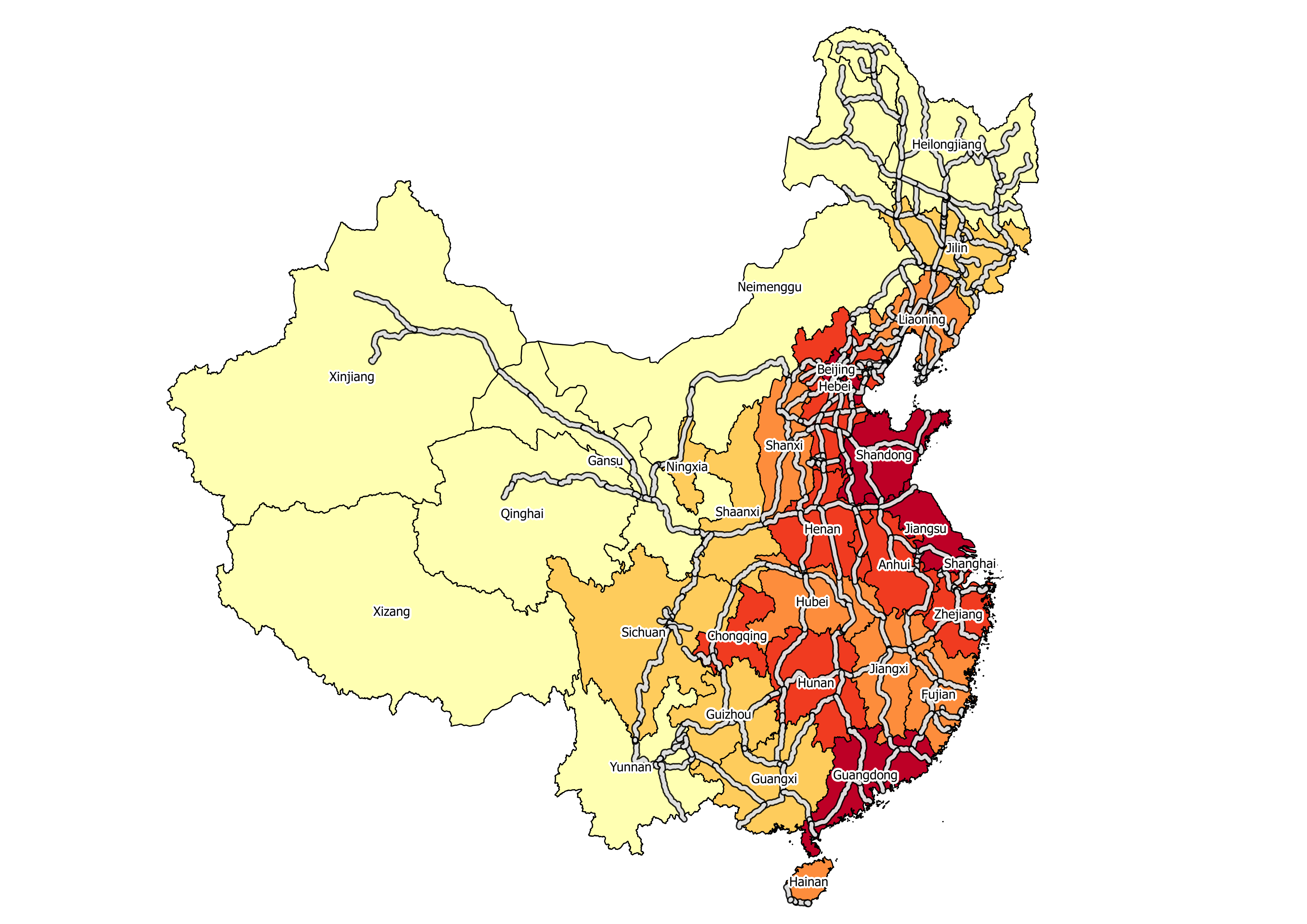 |
| Sample Map - Population Density in China |
2015 China City Statistical Indicators
List of County City Variables (MS Excel) | List of Prefecture City Variables (MS Excel)
| Name | Features | File Type | Year | File Name |
|---|---|---|---|---|
| Cities | points | shapefile | 2015 | 2015_City_Statistics_By_CountyCity_Point.zip |
| Cities | polygons | shapefile | 2015 | 2015_City_Statistics_By_CountyCity_Polygon.zip |
| City Data | excel file | 2015 | CountyCity_Data.zip | |
| Prefectures | points | shapefile | 2015 | 2015_City_Statistics_By_Prefecture_Point.zip |
| Prefectures | polygons | shapefile | 2015 | 2015_City_Statistics_By_Prefecture_Polygon.zip |
| Prefecture Data | excel file | 2015 | Prefecture_Data.zip |
2009 China City Statistical Indicators
...
Detailed 2000 Provincial Data
This data is only available for the following provinces: Beijing, Guangdong, Jiangsu, and Shanghai.
| Name |
|---|
| * 2000 Census Data with GRID Maps (includes township bndys, vector pop grid, and census data) |
| * 2000 County Census Data (similar to datasets listed above) |
| * 2000 Province Census Data (similar to datasets listed above) |
| * 2000 Township Census Data (includes township bndys, reference features, and census data) |
| * Historical County Census Data 1953-2000 (similar to datasets listed above) |